SL 1 Caldera de Los Marteles – El Salviar – Tenteniguada – Valsequillo
Blue tajinaste routes
Starting point:
Caldera de Los Marteles
Altitude: 1528 m
Destination: Valsequillo
Altitude: 580 m
Direction of the route: N-NE-E
Total Distance: 8570 m
Time to cover the Route: 3h
Max. altitude difference: 1001 m
Difficulty rating: Low
The route begins to the north of the Los Marteles Caldera and points in a SW-NE direction. Most of the route crosses the Los Marteles Special Nature Reserve.
The route’s difficulty rating is medium in rainy conditions, and low in the summer.
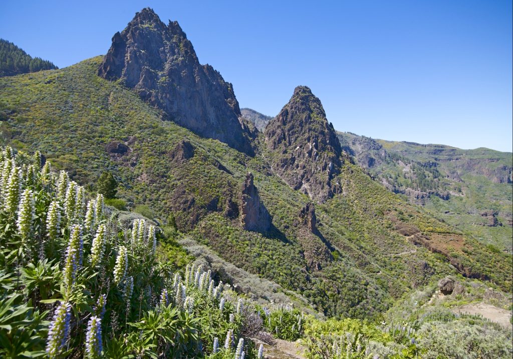
Behind the Caldera de los Marteles, on the GC 130 road, you will find the point: PO Start, this is where the route begins but, first, we will be able to enjoy the view of this caldera from a recent volcanic age, which resulted from a phreatomagmatic episode, i.e. an explosive mixture of water and lava.
The route leads along a forest trail to the left of the area known as “Orillones del Salviar”. Here, we will be crossing a humid mountain summit environment in a pine forest with undergrowth and with wild cherry trees on the sides of the track.
We walk on a ground that is covered in Recent Cycle phreatomagmatic deposits from the eruptions of the Los Marteles Caldera. These are the basis for reforested pine stands (Pinus canariensis). Areas that are free from pine trees are covered in summit bushes, mainly yellow broom (Teline microphylla), accompanied by thyme (Micromeria benthamii), white sage (Sideritis dasygnaphala), Canary Island flatpod (Adenocarpus foliolosus), the summit Marguerite daisy (Argyranthemum adauctum canariensis), giant fennel (Ferula linkii).
After about 510 m. at point: P1 El Salviar caves, we shall reach a point of ethnographic interest. These caves were used by shepherds in the past to shelter their livestock.
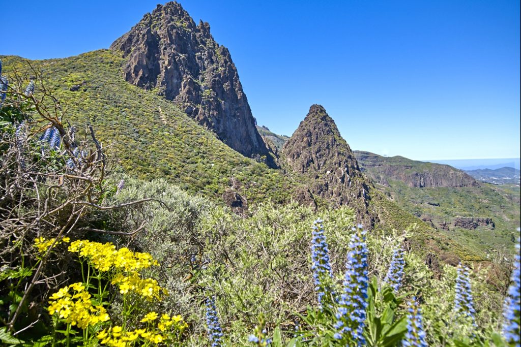
Further on the path forks, we pass a small ravine and follow it along its left bank. After exiting the pine forest, we shall come to a bend with a pond-cave; just before it, an access point to the right leads us to the P2 Start of the footpath. We are now entering “Blue Tajinaste” (Echium callithyrsum) territory, an endemic species from Gran Canaria that is quite abundant in Valsequillo. Together with the tajinaste, we must look for another unique local species, the “Cotton Thistle” (Onopordum carduelinum).The combination formed by blue tajinaste and yellow broom colours the landscape. This rich flora attracts bees, wasps and bumble bees due to the honey-making nature of these species.
We shall continue for about 240 m. and, to our left, we shall come to a spring, point: P3 Spring.
The striking yellow flowers announce the choisy or marjoram (Hypericum grandifolium), endemic to the Macaronesian region. This section now leads through a shady area on the left banks at the head of the ravine. At the beginning of this stretch, we shall cross a valley that is part of the Roque Nublo Cycle, an intermediate stage in the formation of the island.
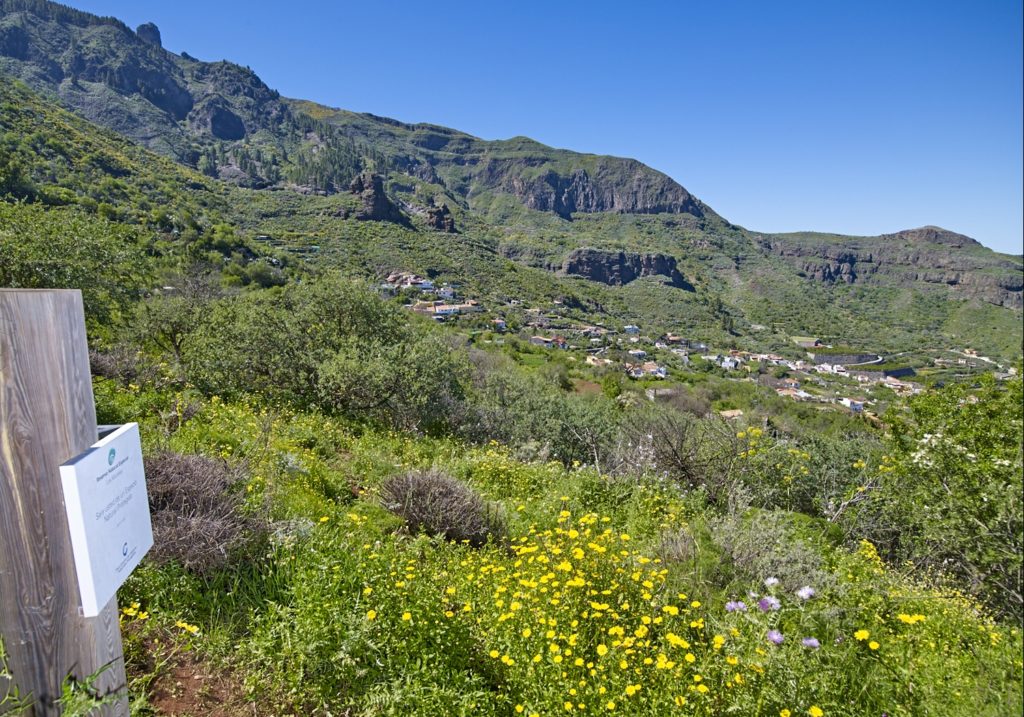
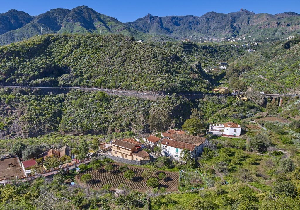
After about 300 metres, the Era Blanca (Threshing ground) appears as a natural viewpoint overlooking Valsequillo at point P4: Era – viewpoint. At this point, we turn east and the surface of the route changes to basanitic flows from the Early Pleistocene. Approximately one kilometer of walk we reach the point: P5 Base of Roque Grande. Roque Grande is a stunning formation, geologically defined as phonolite hauynite plugs belonging to the Pliocene.
The vegetation now grows among the cliffs and is known as rock vegetation. Extremely varied, we can distinguish widespread veroles or bejeques (species of the family Crassulaceae), such as Aichryson laxum, Greenovia aurea, Aeonium spathulatum, Aeonium percarneum, Aeonium simsii, Aeonium manriquerum, Aeonium undulatum; the latter three are endemic to Gran Canaria. Tajinastes also abound, along with species that like moisture, such as the Canary Islands Nettle (Urtica morifolia).
We shall now start the descent down lapilli strewn hills. This is Pleito Hill, where we shall zig-zag down a slippery slope taking care not to fall. We are sorrounded by spicies like rock cabbage (Crambe pritzelii), endemic to Gran Canaria, or the bright flowers of the morgallana (Ranunculus cortusifolios).
We may see some wildlife; species like the buzzard (Buteo buteo insularum), a subspecies endemic to the Canary Islands, the common kestrel (Falco tinnunculus), the plain swift (Apus unicolor), and reptiles such as the Canary Island lizard (Gallotia stehlini), exclusive to the island.
After about 780 m. at the point: P6 End of Footpath, begins a cement road that will take us 300 m further on, where there is a dry chestnut tree, at the point: P7 Rincon de Tenteniguada. This stretch passes through an agricultural and livestock area, with an artisan cheese factory, where we can see plantations of medium-sized trees, fruit trees and houses of ethnographic value. We continue to the center of Casas Blancas by road, we turn to the right for a short stretch of track and continue on another street that takes us to the P8 Tenteniguada.
Here we always go in direction E for a section that runs along a paved track. After traveling 250 m, the first stop is the church and square of San Juan Bautista. The temple is from the early twentieth century, the most interesting is a piece of 16th century of Castilian school imagery known as «San Juan el Chico» which represents the Baptist as a child.
We leave the town, and after walking 260 m, we see from a cultivated area the Tenteniguada ravine, point: P10 Palm Grove of Teneniguada, with the erosive Caldera of Tenteniguada. This Palm Grove of Phoenix Canariensis (Canarian Palm) is the evidence of the thermophilic environment of the area, with species such as wild olive trees (Olea europea cerasiformis) and almond trees (Prunus amygdalus) that color the landscape in February with its flowering.
After 530 meters more, we find several villages of ethnographic value, point: P11 Lindón Hamlet.
After proceeding for 290 m along the asphalt road, we connect on the right with the path that will take us to the channel of the Santiagos ravine, point: P12 Path. We start this section with the panorama of a large part of the geological formations such as the monolithic python of El Helechal mountain, at the end of the Roque Nublo cycle, and next to it a much more recent volcanic cone called Caldereta.
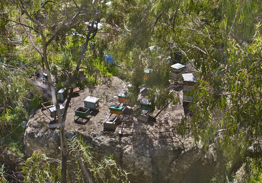
We observe endemic plant species such as the weeping asparagus (Asparagus plocamoides) or the local avifauna with species such as the common buzzard (Buteo buteo insularum), as well as some bee hives (which give their name to the next population nucleus).
The path goes down, after about 800 m of route, the point: P13 Ravine Channel, near an aerial water pipe that crosses the ravine. Thermophilic vegetation has given way to species that demand a more humid habitat.
There is also a strong presence of eucalyptus trees that provide shade to the walker; eucalyptus is a controversial tree, of Australian origin.
The route continues for 430 m along the ravine, leaving the Colmenar Alto neighborhood on your right until you pass under the San Miguel bridge, point: P14, San Miguel Bridge. It is a bridge in two arches made of stone and lime with 13 m of height, 7 of width and 34 of length.
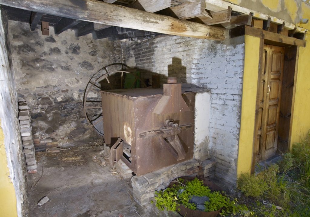
We can deviate towards the right slope of the ravine to observe the hydraulic ingenuity known as the Pérez mill.
We leave the channel of the ravine to go to the area of Colmenar Bajo. About 260 meters from the bridge, you will find one of the most important places from the historical point of view of Valsequillo. Point: P15 El Colmenar barracks.
The original factory of the building is dated in 1530, and was used by a detachment of cavalry: it is formed by a series of dependencies that maintained its military use as a residence until the beginning of the 20th century. It is declared an Asset of Cultural Interest by the Autonomous Community of the Canary Islands. From this point we ascend a cement road about 130 m, until we reach the point: P16 End, historic center of Valsequillo..
Download the route